
A growing fleet of fishers around Australia are collecting vital subsurface ocean data to better understand fisheries and track the broader impacts of climate change.
Commercial fishers have taken part in a successful data collection trial, gathering millions of pieces of information – or data points – from the depths of the ocean in little more than a year.
The trial has been so successful that a growing network of fishers will officially become part of Australia’s Integrated Marine Observing System (IMOS) once the trial ends later this year. IMOS has committed a further three years of funding to expand the data collection from fishers.
Dr Ian Knuckey of Fishwell Consulting says understanding subsurface ocean conditions is critical to improving ocean modelling and fisheries stock assessments in a time of rapidly changing ocean conditions.
He has led the trial as part of the two-year FRDC-funded project ‘Trials of oceanographic data collection on commercial fishing vessels in SE Australia’ (2022-007).
“There is good information about sea surface temperatures. But it is much more difficult to get reliable subsurface ocean information, particularly around Australia’s extensive and remote coastline,” explains Ian.
“It made sense to partner with Australia’s commercial fishing fleet, who are putting gear into the water all the time – a perfect research platform for this type of data collection.”
The project is known as ‘FishSOOP’ (Fisheries Ships of Opportunity Observing Program) and collaborators with Fishwell Consulting include the University of New South Wales (UNSW) and Australia’s Integrated Marine Observing System.
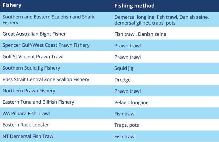
More than 30 vessels around Australia have temperature-depth sensors attached to a diverse range of fishing gear: fish trawl nets, scallop dredges, demersal and pelagic longlines, gillnets, prawn trawl nets, traps and squid jig gear.
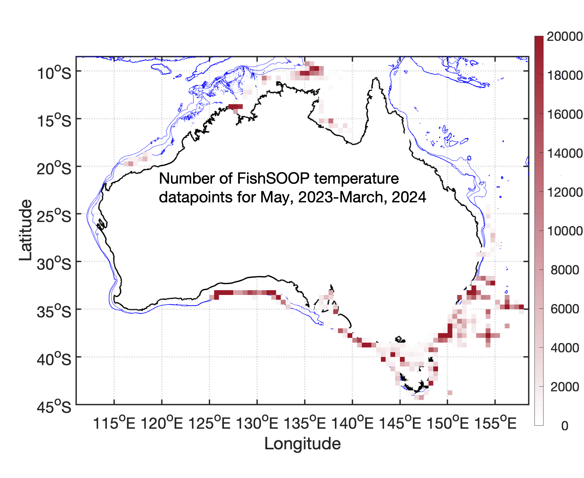
Ian says the participating vessels have gathered over 3 million data points from more than 12,500 fishing sets between the sea surface and depths of 1214 metres.
More than a million datapoints have come from some of Australia’s most remote regions where there has been little or no previous subsurface ocean data. These locations include the Great Australian Bight and the Northern Territory’s Top End.
Simple set-up
Professor Moninya Roughan, an oceanographer with project partner UNSW will lead the transition and possible expansion of the trial’s fisher-based observation network into IMOS operations.
The sensors have been well tested in a similar ocean observation program running in New Zealand since 2018. This program has more than 200 vessels providing data to better understand coastal ocean circulation, connectivity and marine heatwaves.
Time, position, depth and temperature data are recorded when fishing gear is deployed and transferred via Bluetooth to a solar-powered deck box installed on top of the vessel’s wheelhouse. The data is then transferred via the mobile network to the cloud where it is collected and quality checked by the team at UNSW.
Raw data gathered on a vessel is emailed back to the participating fisher for their own information, usually within 24 hours.
The UNSW team ‘clean’ the data, removing any identifying vessel information before adding it to the Australian Ocean Data Network (AODN) portal run by IMOS, where it is available to anyone who wants to access the data. Catch information submitted to fisheries managers is not collected in the data delivered to the AODN.
The hands-off data pathway from the ocean to the cloud, to researchers and back to the vessel in a matter of hours makes the system easy to use and appealing for fishers. “There is little need for human intervention, so fishers can focus on fishing,” explains Moninya.
As the data project moves towards its next phase, Ian highlights the data collection as crucial in helping to understand rapidly changing ocean conditions and the effects of climate change.
“This is having a big impact on how we manage our fisheries,” says Ian. “One of the important things this data will do is to improve our modelling and forecasting of subsurface oceanographic conditions and help us understand their impact on fishery catch rates and stock assessments.”
Dr Ian Knuckey will present the results of the FishSOOP project in a presentation at the biennial industry conference Seafood Directions, in Hobart, Tasmania, from September 10-12, 2024. Get your tickets here.
More about the Integrated Marine Observing System (IMOS)
Australia’s Integrated Marine Observing System (IMOS) is enabled by the National Collaborative Research Infrastructure Strategy (NCRIS). It is operated by a consortium of institutions as an unincorporated joint venture, with the University of Tasmania as Lead Agent. IMOS’s mandate is to implement a wide range of observing equipment throughout Australia’s coastal and open ocean areas, with a key goal to ensure the data collected is used and has a purpose. |
Related FRDC Project
2022-007: Trials of oceanographic data collection on commercial fishing vessels in SE Australia