Victoria’s new data-rich marine ecosystem maps and models have revealed important patterns in the dynamics of Southern Rock Lobster and Blacklip Abalone fisheries, which will improve management of these high-value species
By Gio Braidotti
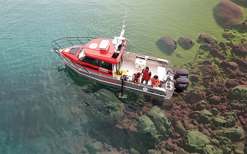 What lies beneath . . . a composite image of Deakin University researchers on the water, with ocean floor mapping overlaid on the right-hand side of the image.
Photo: Deakin University
The amount of sunlight a landscape receives, the shape of the hills and valleys – even the flow of wind – all have clear implications for the vegetation that grows and the animals it supports. It’s a similar story for marine environments, although there are different factors at play.
To better understand what those factors are, the interplay between them and the implications for fish populations, researchers have developed complex models that produce detailed maps of the ocean floor overlaid with myriad physical, biological, and oceanographic information.
This process has been completed recently for Victorian waters as part of an FRDC-funded project focusing specifically on the dynamics of Blacklip Abalone (Haliotis rubra rubra) and Southern Rock Lobster (Jasus edwardsii) fisheries. However, research leader Daniel Ierodiaconou, at Deakin University, says the work can be adapted for many other species.
“There is still a lot of work that needs to be done, but to our knowledge no one before has mapped an ecosystem the way we did and at a state-wide scale – a first in Australia,” Daniel Ierodiaconou says. “Our aim was to understand the primary drivers of productivity on local geographical scales, the resilience of fishing stocks, and threats associated with environmental change.”
The project mapped 2512 kilometres of Victorian coast and inshore waters – about 12,000 square kilometres of water out to three nautical miles – to produce highly detailed, localised and dynamic marine maps. This kind of approach requires expertise from a broad spectrum of disciplines to integrate the many different kinds of data used.
Sea floor data
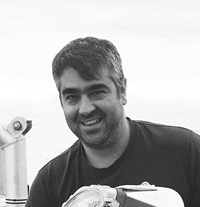 Daniel Ierodiaconou,
Research leader
Several different datasets were combined to map the sea floor. The Victorian Department of Environment, Land, Water and Planning provided bathymetry data (the ocean equivalent of topography) from its Future Coast Program, which was collected to model storm surges. This data, generated by lasers (LiDAR) operated from an aeroplane, provided the first comprehensive statewide pictures of seabed structure.
However, as lasers are not effective where the water depth is 25 metres or more, Deakin University added its own sea floor data, which it has been collecting since 2014, using its in-house multi-beam sonar. This has filled substantial sea floor knowledge gaps, as sonar systems can provide seabed data to characterise deeper reefs and benthic habitats.
The mapping is generally at a scale of between one and 2.5 metres for laser-generated data and less than one metre for sonar data. These sea floor structural maps have been especially useful to the abalone and rock lobster industries, as both target species that rely on sea floor structures for habitat.
Oceanography
The sea floor maps were an important requirement for modelling the hydrodynamic characteristics that influence abalone and rock lobster larval dispersal patterns. Consultants Water Technology developed a 25-year hindcast model that researchers seeded with ‘smart particles’ to mimic the life histories of virtual larvae, comparing modelled dispersal patterns with the real-life recruitment outcomes in the fishery.
Daniel Ierodiaconou says this has provided unprecedented insights into larval dispersal and recruitment across the mapped area, and has identified dominant dispersal pathways. Further integration of catch and fish stocks data dating back to the early 1990s provided by fishers and Victorian fisheries managers has also helped better understand patterns of larval survival.
Combining these elements with information on sea floor structure and oceanographic and sea surface temperature data from the Integrated Marine Observing System (IMOS) has allowed the research team to model biomass changes through time.
Daniel Ierodiaconou says this has provided insight into the physical drivers behind those changes in biomass. For example, the team has identified hotspots for changes in wave energy along Victoria’s southward-facing coasts that have had the greatest ramification for the state’s western and central fisheries.
Variations in where storms occur can lead to changes in wave direction, with potential impacts on both coastal stability and sedimentation patterns in coastal reefs. He says coastal erosion impacts water turbidity, which affects the growth of algal beds. Sediments can inundate reef systems with sand and render them unsuitable for abalone. These changes can also influence the dispersal of larvae.
The research has identified the need for sustained monitoring of oceano-graphic conditions, such as waves, which is now being addressed through the Department of Environment, Land Water and Planning and the IMOS.
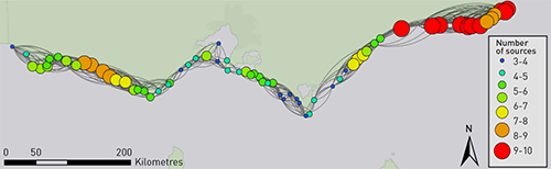 Number of sources contributing to abalone on Victorian reefs. The greater the number of sources, the more resilient an abalone population is likely to be.
Abalone genetics
The team also collected the DNA of Blacklip Abalone across 30 sites, along with data on site seabed structures and environmental conditions. The resulting analysis shows how abalone has responded to environmental changes such as converging ocean currents, sea temperature and wave energy, not just at broad regional scales (10s to 100s of kilometres) but also at local spatial scales (100s to 1000s of metres).
Industry engagement was also a critical part of the project’s success, including feedback on the abalone abundance models and patterns observed.
The research team collaborated with commercial fishers to sample 900 abalone for the genomic component of the study and characterised geomorphic traits of 30 reefs across the state’s three abalone fishing zones.
For abalone and rock lobster, the project has successfully identified important reefs, dominant larval dispersal pathways and the role of selection on larval recruitment processes. For abalone, the project has additionally produced biomass distribution models.
Broader applications
Given the detail of the data, one of its many uses may well be to identify habitat important to abalone and rock lobster that could be subjected to seismic tests, says Markus Nolle, a Southern Rock Lobster fisher and chair of Seafood Industry Victoria. This is an issue of ongoing concern to Victorian fishers.
The data will also provide a guide to the most productive areas of ocean habitat, he says, where investment in restorative technologies, such as reef reseeding or translocation of animals, might get the best return on investment.
The stand-out trend for Daniel Ierodiaconou was the observed rise in sea surface temperatures, particularly on the east coast of Victoria, and the likely negative impact on fisheries productivity.
He says the project outputs will have multiple uses for fishers, conservation and our understanding of our geological history. The sea floor maps are accessible to the public. Other outputs and the models are currently not publicly available, but work is underway to make everything accessible through the Australian Ocean Data Network.
Daniel Ierodiaconou says the broad multi-disciplinary approach was essential to the success of the project. Among the collaborators were Mary Young, Adam Miller, Eric Treml and Craig Sherman of Deakin University, Steve Swearer of the University of Melbourne, Nicholas Murphy of La Trobe University, Jan Strugnell of James Cook University, Harry Gorfine of the Victorian Fisheries Authority in Queenscliff, Victoria, commercial rock lobster fishers and representatives from the three abalone fishing zones.
FRDC Research Code: 2015-025
More information
Daniel Ierodiaconou
daniel.ierodiaconou@deakin.edu.au